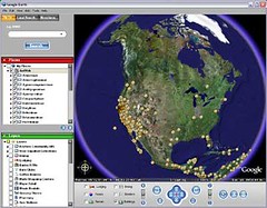
This is a nice example of the kind of thing that can be done when georeferenced specimen data are readily available. Need to think about doing this for iSpecies.
For more on AntWeb and Google Earth vist here .
Friday, January 06, 2006
Subscribe to:
Post Comments (Atom)

3 comments:
These mashups are indeed surprisingly easy to implement. I have used Google Map and Google Earth to permit mapping of North American spiders (http://canadianarachnology.webhop.net). I also found some div overlay javascipting to permit one to "draw" a box on a Google Map and generate a spider species list. The corner coordinates are used as the query strings. A very interesting cgi application called MapServer (http://mapserver.gis.umn.edu/provides far more capabilities than does Google. For instance, ArcView shapefiles & layers can be re-projected on-the-fly. Berkeley Mapper makes use of MapServer as have I in the Nearctic Spider Database.
Matt,
It would be nice if you could provide the community with the source code (PHP?) for your FishMapper application...
Because if it is not source, it is not code! :-)
Cheers,
What do you know Pirates of the Burning Sea Gold. And do you want to know? You can get potbs gold here. And welcome to our website, here you can play games, and you will get potbs Doubloon to play game. I know potbs money, and it is very interesting.Do you want a try, come and view our website, and you will learn how to buy potbs Doubloon. Come and join with us. We are waiting for your coming.
Do want to know the magic of online games, and here you can get more LOTRO Gold. Do you want to have a try? Come on and Lord Of The Rings Gold can make you happy.You can change a lot buy LOTRO Gold for play games. And you can use the cheap Lord Of The Rings Gold do what you want to do in the online game.
Post a Comment